Publications
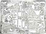
Lhasa Blockprint Map
Lhasa City Development Maps 1948 - 1985 - 1998
The Old City Of Lhasa
Lhasa Old City Vol. II
Barkor Map
Lhasa Valley Map 2001
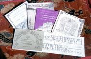
PublicationsLhasa Blockprint Map |
|
||
| The Old City Of Lhasa | |
|
by André Alexander and Pimpim de Azevedo A4, brochure, cover duochrome on handmade Himalayan paper, 96 pages, monochrome, illustrated, published by VFKA/THF in Berlin 1998 (reprinted in Katmandu 1999 and 2000), |
| A Clear Lamp Illuminating The Significance And Origin Of Historic Buildings And Monuments In Lhasa Barkor Street (Lhasa Old City Vol. II) |
|
|
by André Alexander, John Harrison and Pimpim de Azevedo (editors), A5 landscape format, 60 pages with 10 fold-outs, monochrome, illustrated, text in Tibetan, Chinese and Tibetan, published by VFKA / THF in Berlin 1999, printed in Hong Kong, |
| Barkor Map | |
|
Fold-out map, A1, monochrome, published by VFKA / THF in 1999, Berlin and Hong Kong. |
| Lhasa Valley Map 2001 | |
|
The creation of a new and accurate map of Lhasa was part of the work on the Conservation master plan for the old city area The only detailed survey available until then has been the 1 to 1000 1985 municipal survey (which has been recently published in a digitized version elsewhere). However, as any frequent visitor can tell, the city has changed tremendously since then. THF has therefore necessarily made a new map, based on the survey work of the Lhasa Old City Protection Working Group and commercial satellite data from September 2000. Created in AutoCAD 14 for Windows and Adobe Illustrator for Macintosh by Michael Orchard, Yoshi Tada and Ken Okuma. |
Home » Printed Maters » Publications |
Copyright, Tibet Heritage Fund |
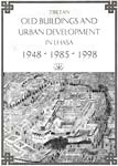 Based on the comparative work done by LAP with the 1948 survey by Peter Aufschnaiter and Heinrich Harrer and the modern development of Lhasa, this series of maps presents an overview of the urban development since 1948 and the fate of the historic buildings. Sources: Peter Aufschnaiter's official survey 1948, official survey data from 1978 (1:5000), 1985 (1:1000) and 1991 (1:200,000), aerial photos (1990-91), satellite data (1965, 1970, 1984, 2000) and own research. Cartography consultant: Alex Müller. Thanks to: Shalu Association. Drawn in 1994 using Graphsoft's MiniCAD 5.0 for Macintosh at the computer lab of the Department of Architecture of Berlin's Hochschule der Kuenste (University for Fine Arts) by MRTZ and André Alexander, updated in 1997.
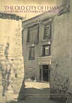 This report explains the historic development of Lhasa city, introduces Tibetan architecture and presents the results of the initial field studies about the present-day old city area of Lhasa. The book was introduced at the 8th International Seminar for Tibetan Studies of the International Association for Tibetan Studies at Indiana University, Bloomington, Indiana USA. The entire text and the illustrations can be downloaded, but an updated print version (with a silk-screen printed cover of handmade Himalayan paper) is available through us or specialized bookstores (e.g. Michael Henss' ASIATICA, book stores in Katmandu and selected outlets in Lhasa).
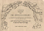 This is the second volume of THF's series of The Old City of Lhasa. It reproduces the results of two years survey work of central Lhasa's Barkor Street, and has hand-drawn scaled elevations of the entire four sides of the circular Barkor Street, two cross-sections and floor plans of all the individual remaining historic buildings. There is also a text about the history of Lhasa and of individual sites written by Mathew Akester and André Alexander. Published with assistance by the German Society for Technical Cooperation (GTZ).
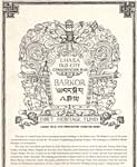 This plan of central Lhasa shows and names 59 remaining historic structures in the Barkor area. The Barkor is one of the main circumambulation routes around the 7th-century Tsuglakhang (Jokhang Temple). The Jokhang is a UNESCO World Heritage List nomination. The map was assembled and hand-drawn by John Harrison, based on survey work by Jian-Jun, Huang Xiao-Lin, Loden, Gelsang, Dakar, Pimpim de Azevedo, Zara Thiessen, Julia Hartmann, Ken Okuma, Koichiro Ichikawa and Yutaka Hirako. The key is based on the 1948 Aufschnaiter and Harrer survey of Lhasa, and has been amended and extended by André Alexander. The Jokhang ground plan is largely based on an official survey by the National Cultural Relics Bureau amended by John Harrison. Published with assistance by the German Society for Technical Cooperation (GTZ).